Watershed FAQ's
A list of our most frequently asked questions and the answers, of course.
What is a Watershed?
A watershed is the area of land where all of the water that is under it or drains off of it goes into the same place.
A watershed is the area of land where all of the water that is under it or drains off of it goes into the same place. John Wesley Powell, scientist geographer, put it best when he said that a watershed is: “that area of land, a bounded hydrologic system, within which all living things are inextricably linked by their common water course and where, as humans settled, simple logic demanded that they become part of a community.” (Source: EPA, 2011)
To find out about the watershed you live in and its health, visit https://www.epa.gov/waterdata/hows-my-waterway
Missouri is part of the largest watershed in the United States, the Mississippi River Basin (Figure 1.a). The Missouri River is the largest watershed in the Mississippi River Basin. The Sac River Watershed lies in the Missouri River Basin just above the Arkansas-Red-White River Basin. The Sac River Watershed is number 34 on the Missouri Watershed Map (Figure 1.b). Click on the map to learn more about the Sac River Watershed.
Figure 1a
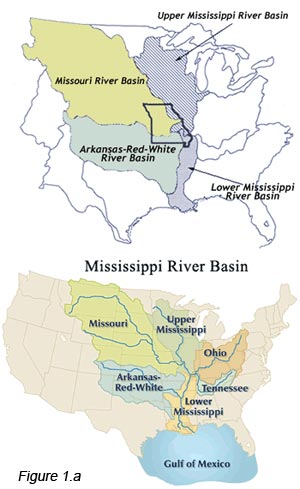
Figure 1b
Non-Point Source Pollution
Non-point source (NPS) pollution is the leading remaining cause of water quality problems in our local watersheds, and our national watersheds. The following information is directly from the U.S. Environmental Protection Agency, and can be found at http://water.epa.gov/polwaste/nps/whatis.cfm
What is non-point source pollution?
Non-point source pollution generally results from land runoff, precipitation, atmospheric deposition, drainage, seepage or hydrologic modification. The term “non-point source” is defined to mean any source of water pollution that does not meet the legal definition of “point source” in section 502(14) of the Clean Water Act. That definition states:
The term “point source” means any discernible, confined and discrete conveyance, including but not limited to any pipe, ditch, channel, tunnel, conduit, well, discrete fissure, container, rolling stock, concentrated animal feeding operation, or vessel or other floating craft, from which pollutants are or may be discharged. This term does not include agricultural storm water discharges and return flows from irrigated agriculture.
Unlike pollution from industrial and sewage treatment plants, nonpoint source (NPS) pollution comes from many diffuse sources. NPS pollution is caused by rainfall or snowmelt moving over and through the ground. As the runoff moves, it picks up and carries away natural and human-made pollutants, finally depositing them into lakes, rivers, wetlands, coastal waters and ground waters.
Non-point source pollution can include
- Excess fertilizers, herbicides and insecticides from agricultural lands and residential areas
- Oil, grease and toxic chemicals from urban runoff and energy production
- Sediment from improperly managed construction sites, crop and forest lands, and eroding stream banks
- Salt from irrigation practices and acid drainage from abandoned mines
- Bacteria and nutrients from livestock, pet wastes and faulty septic systems
- Atmospheric deposition and hydromodification
States report that non-point source pollution is the leading remaining cause of water quality problems. The effects of nonpoint source pollutants on specific waters vary and may not always be fully assessed. However, we know that these pollutants have harmful effects on drinking water supplies, recreation, fisheries and wildlife.
Where Does Springfield’s Drinking Water Come From?
The majority of Springfield’s drinking water comes from surface waters.
Springfield’s Drinking Water Supplies
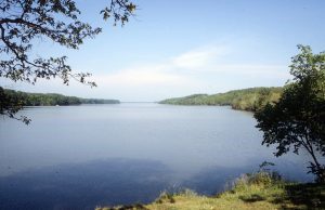 Approximately 80 percent of Springfield’s drinking water comes from surface waters (lakes, rivers) and the rest from ground water (wells, spring). City Utilities’ Fulbright and Blackman Water Treatment Plants use a combination of sources for water treatment, including both surface and ground water. Fulbright is located on the northern edge of Springfield and is served by Fulbright Spring, the original source for the city, along with a deep well and McDaniel Lake. The Blackman plant is in the southeastern corner of the city and receives water from Fellows Lake, Stockton Lake and/or the James River.
Both Fellows and McDaniel Lakes can be supplemented with water from Stockton Lake. Also, three deep wells are located in the distribution system and are used as additional sources when needed. City Utilities works in conjunction with the Watershed Committee of the Ozarks to preserve and protect our watersheds (Information obtained from City Utilities Water Quality Report) Visit City Utilities website for more information https://www.cityutilities.net/customer/water/
How do I get my drinking water well tested?
It’s important to know the facts about testing your well water and your local County Health Department and the EPA are great resources.
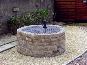
If you are on a private drinking water well EPA recommends to have your well tested at least once a year. Call your local Health Department to check for current water testing fees. For more information on private drinking water wells visit: https://www.epa.gov/privatewells
Springfield-Greene County Health Department Water Testing
- 417-864-1673
- Or visit their website: http://health.springfieldmo.gov/2933/Water-Testing
View our brochure: Protect Your Well
What is stormwater?
The Impact of Stormwater Runoff
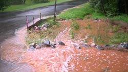 Did you know that the first hour of urban stormwater runoff has a pollution index higher than raw sewage? According to the University of Arkansas Community Design Center, stormwater runoff is a significant source of water pollution. Addressing stormwater-related pollution and flooding is vital to our community and a core mission of the Watershed Committee of the Ozarks.
What is Stormwater Runoff?
Stormwater runoff happens when rain or snowmelt flows over surfaces like driveways, sidewalks, and roads. Unlike natural landscapes, these impervious surfaces prevent water from soaking into the ground, increasing pollution and the risk of flooding. This runoff often carries contaminants such as oil, chemicals, and debris into local waterways, affecting water quality.
Why Stormwater Management Matters
Managing stormwater isn’t just about drainage—it’s about hydration. Allowing water to infiltrate the soil filters pollutants, recharges groundwater, and reduces downstream flooding. By adopting Best Management Practices (BMPs) and Low Impact Development (LID) strategies, we can improve stormwater quality and protect our natural resources.
At the Watershed Center at Valley Water Mill Park, we demonstrate various BMPs in action. Our staff is available to explain how these innovative solutions work to protect our water.
Explore More Resources
- EPA Stormwater Guide: Learn more about stormwater’s impact and solutions from the EPA’s comprehensive guide here.
- Springfield Stormwater Resources: Find out where your neighborhood’s stormwater flows, report pollution, or learn about municipal stormwater (MS4) permits here.
- LID Background: Dive into Low Impact Development strategies here.
- Stormwater BMPs: Explore an extensive list of BMPs from the EPA here.
Get Involved
Join us in protecting our waterways by supporting stormwater management initiatives in your community. Every effort helps reduce pollution, recharge aquifers, and preserve our environment for future generations.
