

 Groundwater is a precious resource, and many people statewide rely on it exclusively for their water supply. The observation wells at the Watershed Center provide valuable groundwater data, as well as an educational tool for the Watershed Center.
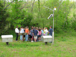
The monitoring wells measure the water levels of the two separate aquifers under the Springfield area. The shallow Springfield Aquifer and the deeper Ozark Aquifer are separated by a layer of rock called Northview Shale–this layer acts as a barrier between the two aquifers. The wells measure the water levels of the Springfield and Ozark Aquifers, and communicate real-time data via satellite. Both wells are at this link, listed under “Greene County.” http://nwis.waterdata.usgs.gov/mo/nwis/current/?type=gw
The two monitoring wells at the Watershed Center are part of a bigger project by the Water Resources Center of the Missouri Department of Natural Resources–adding new wells to the statewide observation well network. The existing network of 75 wells, from 30 to 1800 feet deep, help monitor the status of groundwater resources throughout the state of Missouri. Eighty additional observation wells are planned.
Monitoring Wells Page can be found HERE